Green Infrastructure
Developing GI Corridors for Norfolk
Norfolk County Council (NCC) has been commissioned to deliver a series of maps to inform the Local Plans of the Local Planning Authorities (LPAs) in the county.
These maps are intended to replicate the work undertaken by Norfolk Biodiversity Information Service to inform the Greater Norwich Green Infrastructure Delivery Plan and subsequently the Greater Norwich Joint Core Strategy (JCS). The requirement was to extend the approach taken in this work to cover the whole county, in particular the development of a set of strategic Green Infrastructure (GI) corridors that can be used to target delivery of work and help to mitigate the impacts of development on sensitive sites particular those with Natura 2000 designations (Special Areas of Conservation (SAC) and Special Protection Areas (SPA)).
Green Infrastructure Mapping Report
- Norfolk Green Infrastructure - Strategic GI Corridors and habitat core areas
- Green Infrastructure Assets
Ecological network and opportunity maps for Grassland/Heathland habitats:
Ecological network and opportunity maps for woodland habitats:
Ecological network and opportunity maps for wetland habitats:
Combined networks and opportunity maps:
Flood Management Maps:
- Natural flood management Ecosystem Services Map
- Natural flood management Ecosystem services opportunity Map
Habitat Corridors:
- Broad Grassland and Heathland Corridors Map
- Broad Woodland Corridors Map
- Broad Wetland Corridors Map
- Broad Ecological Corridors Map
Accessible Natural Greenspace Standards (ANGSt)Maps:
Natural England:
Urban Areas within 300m of a 2ha or greater Accessible Greenspace Map
Urban Areas within 2km of a 20ha or greater Accessible Greenspace Map
Urban Areas within 5km of a 100ha or greater Accessible Greenspace Map
Urban Areas within 10km of a 500ha or greater Accessible Greenspace Map
Woodland Trust Woodland Standards (all accessible green space so included not only woodland):
Urban Areas within 500m of a 2ha or greater Accessible Greenspace Map
Urban Areas within 4km of a 20ha or greater Accessible Greenspace Map

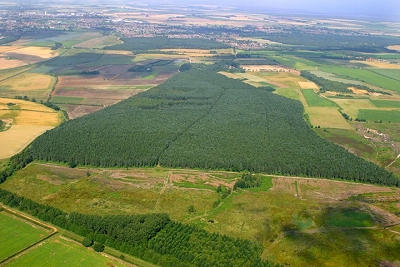
Heathland restoration at Grimston Warren © Mike Page
The importance of creating larger and better connected areas of natural habitat is now recognised as a key strategy for maintaining biodiversity and enabling wildlife to adapt to climate change. Many organisations are now promoting the creation of ecological networks and the use of landscape-scale approaches to conservation. Current initiatives include the RSPB’s Futurescapes and The Wildlife Trusts’ Living Landscapes. In response to Sir John Lawton’s review of England’s wildlife sites, Making Space for Nature, the Government has also made a commitment to establish 12, large-scale Nature Improvement Areas.
Between 2006 and 2007, the Norfolk Wildlife Trust undertook an ecological network mapping project on behalf of the Biodiversity Partnership. This ambitious project led to two overview reports for the county as well as more detailed district-by-district assessments. The maps produced by the project identify the most important existing biodiversity areas in Norfolk as well as opportunities for enhancing, creating and linking habitats.
Amongst other benefits, the project led to a significant increase in awareness and understanding among many different stakeholders of the importance of ecological networks. The results of the project were also used to inform policy, including the Norfolk Local Area Agreement and many Local Development Frameworks (see, for example, the Core Strategy in the North Norfolk LDF).
To download the reports of the Norfolk ecological network mapping project, please click on the links below.
County-level Reports
pdf Making Space for Wildlife and People (2,370 KB)
pdf Report of the Ecological Network Mapping Project for Norfolk (1,363 KB)
District-level Reports
Breckland District:
pdf Ecological Network Report (114 KB)
word document Ecological Network Map (735 KB)
Broadland District:
Ecological Network Report (176 KB)
word document Ecological Network Map (396 KB)
Gt Yarmouth Borough:
pdf Ecological Network Report (145 KB)
word document Ecological Network Map (280 KB)
North Norfolk District:
pdf Ecological Network Report (163 KB)
pdf Ecological Network Map (446 KB)
Norwich:
pdf Ecological Network Report and Map (138 KB)
South Norfolk District:
pdf Ecological Network Report (129 KB)
word document Ecological Network Map (473 KB)
West Norfolk District:
pdf Ecological Network Report (331 KB)
word document Ecological Network Map (580 KB)

